
The wind environment has a major influence on the viability of any wind energy project in terms energy output and turbine wear. Numerous factors such as wind speed and direction; turbulence, shear, veer, inflow angle and atmospheric stability can have significant impacts on a wind turbine’s performance. Accurate prediction of pre-construction yield with the real-world post-construction yield of a wind project at all scales remains a challenge.
Site feasibility assessment:
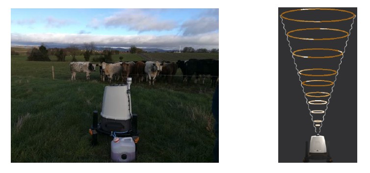
- Light detection and ranging (LiDAR) technologies now give the opportunity to measure winds at multiple heights at such locations in the absence of met masts.
- The ZX vertical profiling LiDAR, Fig. 1, available at CREDIT Technology Gateway can measure wind speeds from 10 metres to 300 metres above the ground making it suitable for all sizes of wind turbine available today.
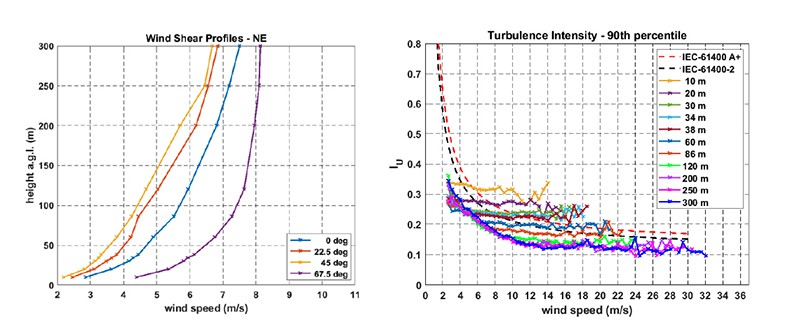
- CREDIT Gateway can assist companies with site-specific wind measurements that can be used to can better inform wind flow models in energy predictions and assess wind shear and turbulence, Fig. 2, leading to improvements in micro-siting turbines at your site.
Wind turbine yaw error assessment
- For optimum power output, a wind turbine’s rotor should remain perpendicular to the oncoming wind as much as possible. Any measured difference between the wind direction and the nacelle position of the turbine is known as yaw error. When the yaw error is 0°, the turbine is ideally pointing directly into the wind. When a wind turbine’s rotor is not pointing directly into the wind, the turbine is experiencing what is known as yaw misalignment.
- There are two main types of yaw misalignment, dynamic and static. Dynamic yaw misalignment occurs frequently as the wind naturally changes direction from the nacelle direction. Based on wind information from a nacelle mounted wind sensor, a wind turbine will use its yaw motors to move the nacelle back to 0° yaw error, temporarily eliminating the dynamic yaw misalignment. Static yaw misalignment is more challenging to assess. It occurs when a wind turbine is not pointing directly into the wind, even when the yaw error measured by the nacelle wind sensor is 0°. This means that it is invisible to the turbine’s controller and is not corrected for, as in the dynamic case.
- Static yaw error may be caused by wind incorrect wind sensor mounting on the nacelle or by incorrect software parameter settings in the turbine’s controller. Therefore, static yaw misalignment can result in the rotor never facing directly into the wind with a constant directional offset. This can impact annual revenues.
The Epsiline LiDAR available at CREDIT Gateway is all-in-one nacelle-mounted short-range LiDAR solution for independent wind turbine monitoring and optimization, Fig. 3, particularly in relation to yaw misalignment. Annual energy losses can be 0.5% loss for 4° static yaw misalignment, increasing rapidly to 2.5% reduction with a 9° static yaw misalignment. As such, it is essential to monitor yaw misalignment continuously.
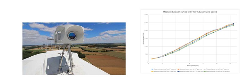
The Epsiline LiDAR unit offers the potential of relatively low cost solution to assessing static yaw misalignment on currently operating wind turbines.
New long range side scanning LiDAR on the way
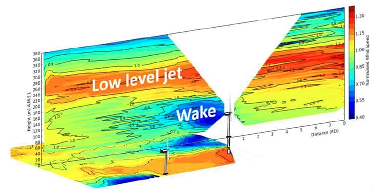
Towards the end of 2022, CREDIT Gateway will be acquiring a new long range all-sky 3D scanning LiDAR with wind measurement capabilities out to a distance of 3 km and possibly up to 6 km. The will give interested companies the ability to carry out wind resource measurements from a single location to multiple points across an entire wind farm project site as well as offshore applications. It can also be used for wake measurement of single or multiple wind turbines to assess complex flow within wind farms, Fig. 4, thereby helping to optimise a given wind project for maximum yield.
Why use CREDIT Technology Gateway?
Researchers in CREDIT Gateway have many years of wind resource assessment experience and have been involved with a number of international IEC and IEA committees in the wind energy area.
The available LiDAR devices are easy to deploy and can begin to generate data at a given site almost immediately.
The data can be incorporated with industry wind flow models to model to assess wind flow across a given site.
Large energy users interested in behind-the-meter wind at a commercial scale would greatly benefit from detailed site feasibility studies using LiDAR in the absence of met masts to optimise resource and load matching at their sites.
Wind farms with undeforming older turbines have the opportunity to assess yaw error and potentially improve annual energy yields and revenue.
Wind farm developments both onshore and offshore would benefit from long range wind measurement capability to help optimise their projects.